Casco Bay Has 16,655 Acres of Tidal Habitats
Over a Hundred Acres of Tidal Marshes Restored Through Culvert Replacement
WHY IT MATTERS
The integrity of Casco Bay’s ecosystems depends on the function and persistence of tidal marshes, tidal flats and beaches, and rocky intertidal areas, which serve as critical habitats for fish, shellfish, birds, plants, and other organisms. These coastal habitats also help protect human communities from flooding, storms, pollution, and the effects of climate change.
Tidal marshes and flats are highly productive sources of food for many species, and they reduce harmful effects of greenhouse gas emissions by absorbing carbon dioxide and burying the carbon in soils. Rocky intertidal areas support rockweed and other seaweeds that absorb nutrients from the water and provide shelter to numerous species.
Human activities can degrade coastal habitats through land development, road crossings of tidal marshes, and nutrient enrichment and other types of pollution. Dams on rivers and streams interrupt the flow of sediments needed to form and maintain tidal marshes and flats. Sea level rise and coastal flooding are affecting tidal marshes and causing shifts in vegetation, especially in marshes already degraded by other human activities.
STATUS
According to classifications assigned by the National Wetlands Inventory, there are 16,655 acres of intertidal habitats in Casco Bay. This includes 11,055 acres of tidal flats and beaches, 3,241 acres of rocky intertidal, and 2,359 acres of tidal marsh.Total Area of Coastal Habitats
Tidal Marshes Impaired by Over 100 Road Crossings and Dams
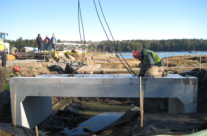
Replacing Undersized Culverts Restores 116 Acres of Tidal Marsh
Coastwise Road crossings
Maine Coastal Program and collaborating partners, including CBEP, are developing a voluntary set of science-based, field-tested best practices for designing climate-resilient tidal road crossings. CoastWise aims to reverse centuries of impacts to marshes and other tidal habitats by designing safe, low-maintenance crossings scaled to accommodate sea level rise and restore natural tidal flow. Training sessions will also encourage municipalities to utilize a definitive statewide atlas of tidal crossings recently developed by Maine Coastal Program.monitoring coastal habitats
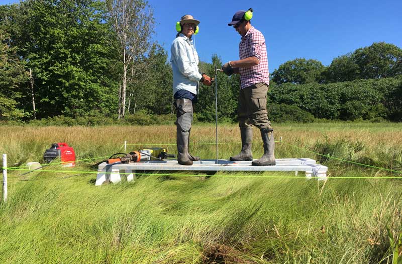
Scientists agree on the need to establish long-term sentinel monitoring stations aimed at tracking changes to coastal habitats. One example is Maine Coastal Program’s statewide network of salt marsh monitoring sites, including one in Maquoit Bay. Using Rod Surface Elevation Tables (rSETs), precise annual measurements of sediment elevations are collected annually. Researchers hope that eventually these data will provide insights into the rates of marsh elevation change relative to sea level rise, as well as an improved understanding of the processes driving these changes.Successes and challenges
- Tidal flats and marshes are vulnerable to accelerating sea level rise, which may alter sediment deposition processes and cause erosion. As tidal marsh erodes, it typically converts to mudflats, but both habitats depend on delivery of sediment to maintain elevations within the tidal range. It is unclear whether sediment delivery will be adequate to maintain marshes and mudflats in Casco Bay. Protection of low-lying uplands adjacent to tidal marshes accommodates expansion of new marsh inland as the seaward edge erodes, while safeguarding water quality and activities such as shellfish harvesting and aquaculture that depend on it.
- Where roads and other structures restrict tidal flow to marshes, and where conditions permit, restoration of tidal exchange can enhance resilience to sea level rise and other stressors. Brunswick, Harpswell, Phippsburg, and South Portland have recently implemented marsh restoration efforts, resulting in enhanced tidal exchange into 116 acres of marsh, or 6.9% of the Bay’s total marsh area.
- Establishment and expansion of non-native species such as European green crab and the common reed, Phragmites australis, can result in sudden ecological shifts that may be difficult to reverse. Healthy marsh ecosystems are better able to withstand these and other threats.
View a PDF version of this page that can be downloaded and printed.
View references, further reading, and a summary of methods and data sources.
STATE OF CASCO BAY
Drivers & Stressors
What’s Affecting the Bay?
Human Connections
What’s Being Done?
If you would like to receive a printed State of Casco Bay report, send an email request to cbep@maine.edu.
This document has been funded by the U.S. Environmental Protection Agency under Cooperative Agreements #CE00A00348-0 and #CE00A00662-0 with the University of Southern Maine.
Suggested citation: Casco Bay Estuary Partnership. State of Casco Bay, 6th Edition (2021).

